Posts

Showing posts with the label iceland

southern peninsula region of Iceland

Image
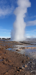
Southern peninsula region of Iceland was our next stop. It is a desolate region of lava rocks covered with snow but with a lot of geothermal springs which gives the country the ability to generate power using this hot water not only for domestic consumption but also for industrial plants. Southern Peninsula(Icelandic: Suðurnes) Reykjanesskagi(pronounced [ˈreiːcanɛsˌskaiːjɪ]) or Reykjanes Peninsu la is a region in southwest Iceland. It was named after Reykjanes, the southwestern tip of Reykjanesskagi. The region has a population of more than 25,000 (2018) and is one of the more densely populated parts of the island. The administrative centre is Keflavík, which had 7,000 residents when it merged with the nearby town of Njarðvík and Hafnir several years ago to create Reykjanesbær, which now (feb 2019) is the largest settlement outside the Greater Reykjavík area; on 1 January 2013 the town had a population of 14,231, but 17,805 in 2018. The region is the location of Keflav

Bridge across the Continents of Europe and America in Iceland - Sarada's travelogue

Image
Our next stop was the bridge between the 2 continental plates - Eurasian and north American tectonic plates. So if you cross the bridge you are geographically in America but without Visa. It was -2° freezing and quite windy though there is a path. The path was covered with sleet and was quite slippery. The wind was so strong that we were getting pushed. A glove was dropped and was blown  so far away in a jiffy. Probably in a better weather conditions we would have enjoyed the whole thing but even in the bad weather was happy to see the fissure between the two plates. Here is the info about it The Bridge between Continents or Midlina is a 15 meter (50 ft) footbridge in the Reykjanes Peninsula spanning a gaping rift between the Eurasian and North American tectonic plates. ... These major tectonic plates drift apart by the Earth's forces, few centimeters each year

viking Museum - Sarada's travelogue

Image
Tuesday the 12th March - we were supposed to visit the  Seljalandsfoss - rated as the First Most beautiful waterfalls in the World - But nature had its own plans for us. When we came down to have our breakfast and then get on to the bus for the road trip to the falls and Vik - the black sand beach - we were so thrilled to see snow fall.  Few of us got outside to take photos of the falling snow not realizing  that this is going to change our plans. Our guide came in and said there is a storm advisory and the road which leads to the waterfalls will be closed by 1200 noon and so she said we cant undertake that journey but said we can go the southern way to see few things. So we went sight seeing in the southern direction passing through the keflavik airport.   What a day it was snowy, windy and very very cold.    Our first stop was a near a small building which houses the replica of the Viking boat which was used to cross the Atlantic ocean to reach United States much before Colu

Perlan city centre, Reykjavik - Sarada's travelogue

Image
Perlan the city centre seems to be on a small hill top. We just saw the outside of it .  It means Pearl Here is the info Capping Öskjuhlíð hill, the Perlan building is one of Reykjavík’s instantly recognisable landmarks Perlan was designed by architect Ingimundur Sveinsson and opened to the public on 21 June 1991. The building is composed of an immense glass dome that sits on six hot-water tanks, each carrying 4 million litres of geothermal hot water. All of this is supported by a colossal steel frame, which serves important functions in addition to holding everything together. The framework, hollow on the inside, is actually a gigantic radiator. In the winter when it is cold, hot water runs through the frame, while cold water is used in the summertime. The first museum inside opened in summer, and Perlan is rolliexhibitions and attractions into 2018. The showpiece is the ambitious Glaciers and Ice exhibition, where you’ll put on cold weather gear and make your way through

sun voyager sculpture - Reykjavik - Sarada's travelogue

Image
s t The sun Voyager sculpture. A photo stop in the freezing night Info about it Sun Voyager is a sculpture by Jón Gunnar Árnason, located next to the Sæbraut road in Reykjavík, Iceland. Sun Voyager is described as a dreamboat, or an ode to the sun. The artist intended it to convey the promise of undiscovered territory, a dream of hope, progress and freedom. Artist: Jón Gunnar Árnason Opened: 1990 Created: 199

iconic church of Iceland - Sarada's travelogue

Image
The local city tour of Iceland was just a time filled before we went for our dinner  on Monday the 11th march. We had a photo shoot tour. Here are the local sightseeing places. The iconic church of Iceland Hallgrimskirkja, Reykjavik's Most Famous Church. Hallgrimskirkja (the church of Hallgrimur), is a Lutheran Church located in the city of Reykjavík. The towering structure stands 74 meters tall, making it Iceland's tallest church, and the country's sixth-tallest building overall.
Image
Horse riding in Iceland a much touted activity - the write up talks about meandering ride through volcanic pathways- a beautiful and much anticipated event. In reality you get helped to get on  a horse, get practice to sit on it and ride for about an hour supposedly. The group follows the trainer stopping here and there and ride around the perimeter of the little farm and that's it  No more and no less  But like a small walk on the horse in an tourist place.  and one  more fun activity a thrill of getting on a horse and holding its reins (the horse knows the route and follows the leader) you just sit on it. The best thing was The horses were all looking so wonderful and the trainers were so good.  thats all.

Blue Lagoon, Iceland - Sarada's travelogue

Image
oday's first activity blue lagoon. A man made geothermal outlet for the geothermal water mixed with sea water - a group fun time for not more than half an hour. Basically you wade through warm water not knowing where you are going in that mist. the famous face mask that comes with the package is silica gel which is given as dollops and you apply it on your face and wash it off in 10mts.  In I celand freezing temperatures it is a refreshing time in warm water. It is nothing more nothing less. Here is info from wiki  The original Blue lagoon - A man made logoon is which more than 27 years old.  A favorite amongst tourists to Ireland The Blue Lagoon (Icelandic: Bláa lónið) is a geothermal spa in southwestern Iceland. The spa is located in a lava field near Grindavík on the Reykjanes Peninsula, in a location favorable for geothermal power, and is supplied by water used in the nearby Svartsengi geothermal power station. The Blue Lagoon is approximately 20 km (12 mi

Geysir Iceland - Sarada's travelogue

Image
Geyser the hot spring erupting out of the ground every 5 minutes like a clock work. Amazing nature. Of course for people who have seen old geyser in California it is nothing new. The build up to the eruption leads to the build up of all the people waiting to watch it. After few small small ones it was worth the wait. Geysir - a common word world over meaning the equipment which helps us to get hot water. here the nature is providing us the hot water. Geysir (Icelandic pronunciation: [ˈkeːisɪr̥] sometimes known as The Great Geysir, is a geyser in southwestern Iceland. It was the first geyser described in a printed source and the first known to modern Europeans.[citation needed] The English word geyser (a periodically spouting hot spring) derives from Geysir. The name Geysir itself is derived from the Icelandic verb geysa("to gush") the verb from Old Norse. Geysir lies in the Haukadalur valley on the slopes of Laugarfjall hill, which is also the home to Strokk

what to take for a trip to iceland

Planning to visit Iceland to see the Northern lights - the season is between september to March.  We travelled to Iceland during March 2nd week and here is the list of things that became an essential part of our travel  insulated waterproof and windproof winter jacket  Thermal underwear Woolen or fleece sweaters woollen socks  Also carry normal socks for any city side visits  waterproof winter boots - very very essential to walk on ice when it snows If you are planning on going to the glaciers then get ice cleats too ice stick for walking on the glaciers if possible take an extra pair of shoes in case your boots gets muddy and wet. winter hat with ear flops, waterproof gloves - one thin inner one and then a thick outer one scarf jeans thermos flask reusable water bottle flashlight  moisturizer and lip balm camera and other accessories power bank as the phone batteries go down quick in cold weather travel adapter sun glasses swimsuit raincoat or poncho  req

Reykjavik

Image
Finally landed in Reykjavik capital of island at 800pm. Our Delhi Helsinki flight became a 9.5 hours flight due to detour avoiding Pakistan airspace. The connecting flight was kept waiting as 55 from this flight had to take the connection. A hearty Indian meal welcomed us the tired and hungry travelers here is info about rey-ka-vik Reykjavik Reykjavík is the capital and largest city of Iceland and is located in southwestern Iceland, on the southern shore of Faxa Bay. Its latitude is 64°08' N, making it the world's northernmost capital of a sovereign state. With a population of around 123,300 (and over 216,940 in the Capital Region), it is the heart of Iceland's cultural, economic and governmental activity, and is a popular tourist destination. Reykjavík is believed to be the location of the first permanent settlement in Iceland, which, according to Ingólfr Arnarson, was established in AD 874. Until the 19th century, there was no

Gulfoss Iceland - Sarada's travelogue

Gullfoss (Golden Waterfall) is an iconic waterfall of Iceland offering a spectacular view of the forces and beauty of untouched nature. Gullfoss is part of the Golden Circle tour, located in South Iceland on the Hvítá (White) river which is fed by Iceland´s second biggest glacier, the Langjökull. The water plummets down 32 meters in two stages into a rugged canyon which walls reach up to 70 meters in height. On a sunny day shimmering rainbow can be seen over the falls. The wide  Hvítá  river flows southward, and about a kilometre above the falls it turns sharply to the right and flows down into a wide curved three-step "staircase" and then abruptly plunges in two stages (11 metres or 36 feet, and 21 metres or 69 feet) into a crevice 32 metres (105 ft) deep. The crevice, about 20 metres (66 ft) wide and 2.5 kilometres (1.6 mi) in length, extends perpendicular to the flow of the river. The average amount of water running down the waterfall is 140 cubic metres (4,900 cu ft)

Thingvellir, Iceland - Sarada's travelogue

We are here on 9th March.  While we were worried about what would be the weather conditions  we were blessed with a sunny day.  While all of us were thermals,sweaters then outer layer fleece jackets initially it was very cold that we had to wear gloves and everytime we had to remove the gloves to take a photo but later on got used to it.  When I read it as park I was imagining a forest area but it was only volcanic rock outcrops. Here is a write up from wikipedia Þingvellir anglicised as Thingvellir, is a national park in the municipality of Bláskógabyggð in southwestern Iceland, about 40 km northeast of Iceland's capital, Reykjavík. Þingvellir is a site of historical, cultural, and geological significance, and is one of the most popular tourist destinations in Iceland. The park lies in a rift valley that marks the crest of the Mid-Atlantic Ridge and the boundary between the North American and Eurasian tectonic plates. To its south lies Þingvallavatn, the largest natural lake